So off I went, heading north. Soon I was crossing Maryland (with a concealed handgun--suck that, Maryland gun-banners!) and in no time at all, I was flying over lush Pennsylvania farm country. (Click on the pics to enlarge 'em)

It's amazing, but you can actually smell the cows at 3,500 feet!
All too quickly though, I ran out of flat farmland and found myself in the mountainous terrain of mid-southern PA. Mountain flying kinda concerns me, because if there's a problem and the prop stops spinning, decent landing places are scarce. I smile thinking back on last summer when I went out to western Kentucky to get this plane. Back then I did't give the terrain below--or the weather--a thought. I just jumped in and launched, and got a schooling in both before I was back home. But I've learned a lot more since then, so I climb higher to allow me to stretch my glide if need be. Fortunately the mountain ridges seem to be old glacial moraines, remnants of the last ice age, and they've got lots of farm and other developed land in between, so no matter what happens, I've got landing sites.
This golf course would be a nice spot. Cessna playing through!

Of course I can't see a golf course without thinking of my dad. Golf was his thing. Miss ya, Pop!
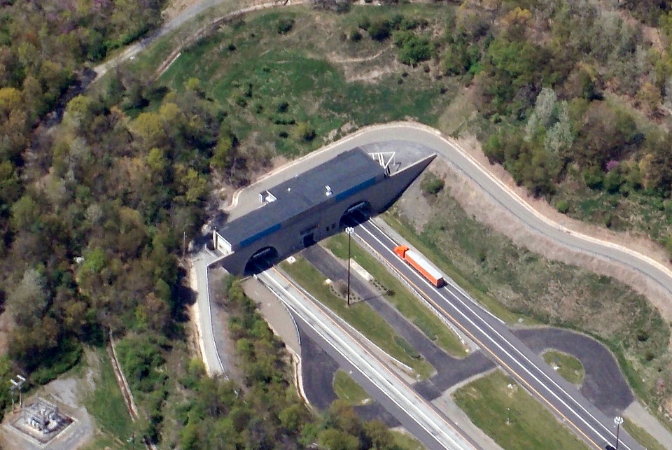
Here's a highway tunnel cutting through one of the ridges.

And here's a close-up shot of a truck going into the tunnel.
Antique GPS says we're on course, 32NM out, at 103 knots. (Why aircraft have to use nautical miles, I do not know.)

More views of the ridges with the farms in between. It was beautiful up there today.


Here's the valley with my target airport in it...But where's the airport?

Oh, there it is--way off in the distance. Hell, that's not a runway! It's a driveway with numbers and a wind sock!

But I got her down on the second try after coming in way too fast on the first approach. That's when I found our that the runway itself is on a hill, and once flared for landing, you can't see the far end of it (which isn't far away at all).

Bump, bump, bump, bump! Either the front gear is still jaked, or else this is the worst runway ever. Note to self: Don't combine test flights with cross-country trips from now on.
I turned around and took off again, and decided to try my luck at Mifflin County airport (RVL) since it was on the flight path.

I greased it in here slick as you please, so maybe it was the runway at the last place. We'll see.
More ridgelines on the route home.

Hey farmer guy! Your yard's a mess! The eye in the sky sees all.

And soon enough, I was back home. Another silk-smooth landing suggests that maybe the gear is ok now, and back to the tie-down.

2.7 hours logged. Happy day.
Heh. You should report that guy's lawn to "American Pickers"!!
ReplyDeleteNice the repairs worked out! Looks like it was a grand day.
ReplyDeleteYep, I can remember flying back in Illinois and smelling the cows.
ReplyDeleteThere was also a rendering plant on the South side of town.
You did NOT want to fly downwind of it!
Nicely done! :-) And yeah a touch and go before you departed the area 'would' have been a good idea! :-)
ReplyDelete"Cessna playing through!" Heh.
ReplyDeleteI noticed your home airport is MRB -- 1 mile from my house.
ReplyDeleteJoe Myers
Sure is, Joe. Come on out sometime.
ReplyDelete@ Old NFO: Next time, for sure. This is how we learn.
ReplyDeleteI think the reason for nautical miles has to do with aeronautical charts being lat long based and 6000' ( a nautical mile) goes in to 360 degrees and/or 60 seconds/60 minutes easier than 5280. It certainly made planning a low level route and air to ground attack easier. :-)
ReplyDelete@ Juvat: Interesting answer. Thanks for that. My problem now is that some of my aircraft's instruments are still standard MPH--the airspeed indicator, for example--so there's a fair bit of math going back and forth on things. If I was still doing time/speed based navigation instead of using the GPS, it'd really be a pain, what with the charts being nautical.
ReplyDeleteAnd of course the benefit only flows one way; the FAA won't let me engage in air-ground attack...I've asked. ;-)
Great pictures.Thank-you for sharing them
ReplyDelete